

Seeing the Big Picture
PHOTO ESSAY: Canada's 'transformative' national trade corridor is right around the corner – literally – for people who live near the railways and roadways driving industrial development in Saint John


Hidden behind vaguely encouraging phrases about ‘exciting opportunities’, ‘key roles’ and ‘transportation bottlenecks’ is a simple fact: the last few kilometres of Canada’s ‘transformative’ national trade corridor run through a lot of towns and neighbourhoods en route to Port Saint John.
Prime Minister Mark Carney’s intention to quickly invest in building out significant East-West transportation infrastructure – be it roads, rails or pipelines – is great news for New Brunswick’s economy, currently battening down against American economic aggression.
While a plurality of Canadians just voted in favour of that plan, I suspect a lot don’t understand what that means at street level, particularly in Saint John, where industry and residents cohabitate in sometimes close quarters.
To help wrap our heads around Canada’s imminent industrialization push, Side Walks’ photo editor Michael Hawkins took his drone out for a ride through West Saint John for our first photo essay.
Michael’s six wide-angle aerial photos ask us to consider this fundamental question: How will our national ambitions translate into local realities?
This is the starting point for a conversation about New Brunswick’s role in Canada’s national trade corridor and how the era of change we voted for comes home.
A viewing note: We recommend, for best results, view Michael’s photos on a tablet, laptop or desktop. We also recommend pulling up your favourite digital map website to help orient you.
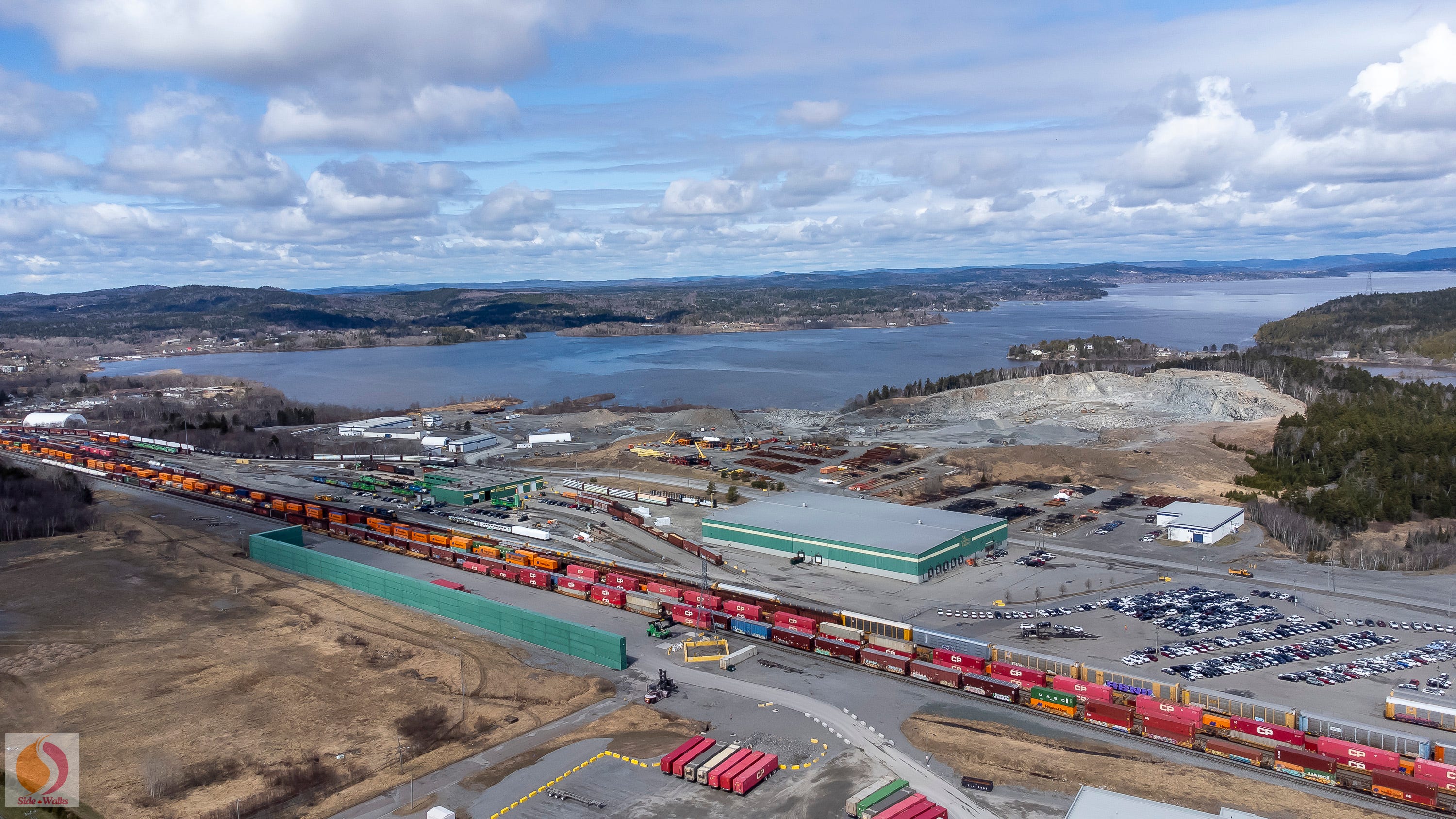
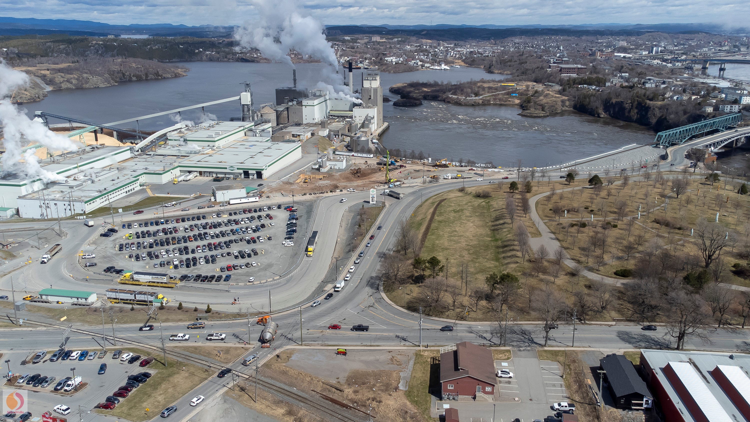
Starting from the West, Canada’s National Trade Corridor Follows the St. John River into Saint John
We begin at J.D. Irving Limited’s (JDI) Logistics Park, an intermodal terminal for moving goods between trains and trucks using NB Southern’s short-track rail line, which crosses Simms Corner en route to Port Saint John.

Bordering South Bay is the Bald Mountain Rock Quarry, which JDI intends to convert into a new wood chip production facility to feed its new turbine and green energy generator, the centrepiece of its $1B Next Gen project at Irving Pulp and Paper, located about three kilometres south, at Simms Corner.
Randolph Island, a small residential enclave, sits behind the quarry, connected by road to the western edge of Milford, which is home to Dominion Park, a municipal park and beach, facing out into the St. John River.
The water between the quarry and the far left side of the photo is South Bay. The houses that dot the far side of South Bay are located off Westfield Road.
Following the riverbank past the rail lines you’ll see riverfront properties in the neighbourhoods of South Bay, Acamac (directly across from Randolph Island), Ketepec, Belmont, Morna Heights, and along the horizon line, the town of Grand Bay-Westfield.
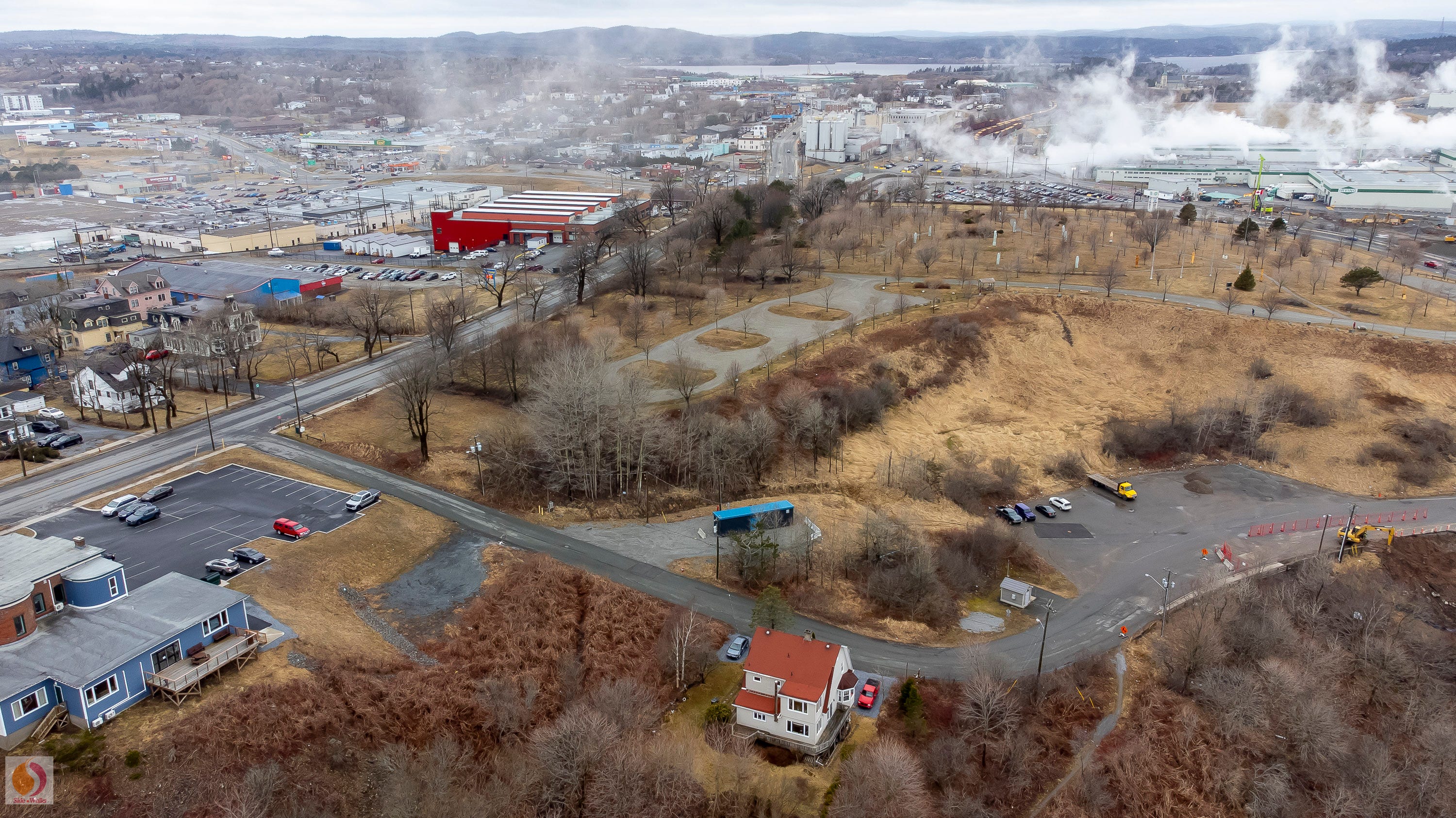
Looking East at Saint John’s Industrial-Residential Mix, Encircled By Land, River & Sea
Hi there. We’re so glad you stopped by.
Side Walks is fully funded by readers and organizations that support our mission to produce local journalism. If you’re enjoying this story, please consider becoming a paid subscriber, $8/month or $80/year. You can also sign up for a free subscription. All subscriptions deliver Side Walks directly to your email inbox, and you can also read along on the Substack app.
Think of us as your friendly neighbourhood buskers setting fire to complacency while juggling a mix of coverage, commentary and culture – and this is the point in the show where we pass the hat. We appreciate your support!
For our paying subscribers, thank you! The rest of our photo essay is just for you. Enjoy and be sure to share your thoughts below.
Moving right to left, is the Milford neighbourhood. Green Head Road, is the only entrance, via the overpass at the Logistics Park and rail line, curving past Doiron’s Sports (blue building, brown roof) and St. Rose Catholic Church, (moss green building with steeple).
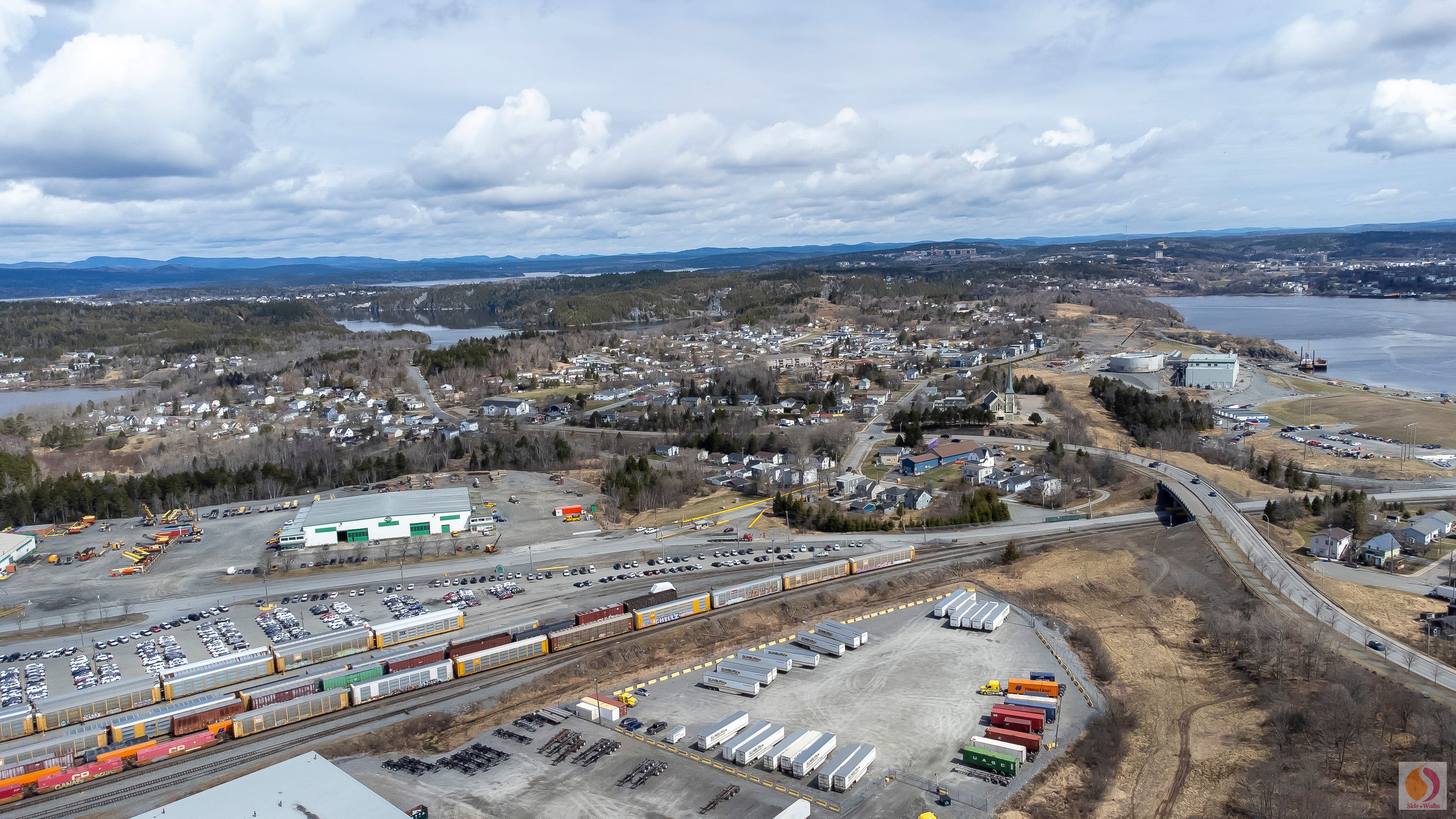
Next is the intersection of Green Head Road and Milford Road, with Green Head Road continuing west (left in the photo), along the border of the Logistics Park, before connecting with Dominion Park Road, its houses visible to the far left.
To the right of St. Rose Church is the edge of Irving Pulp and Paper’s property, with a floating roof storage tank, office trailers, a parking lot and a small river wharf.
This photo also illustrates the twists and turns of the St. John River as it makes it way to Reversing Falls, where it meets the Bay of Fundy and Saint John Harbour.
To the far left, you can see the river’s grand bay, formed by the meeting of the St. John River and its largest tributary, the Kennebecasis River, which can be seen in the background. Kennebecasis Island is visible, and behind it,the Kingston Peninsula. In front sits Stanley Gardens (ring of white houses, left).
The Saint John Regional Hospital is the brown building on the hilltop, and beside it the University of New Brunswick, Saint John. Together, they sit at the highest point in the photo. To the left is Millidgeville; to the right, the city’s North End.
To the South, the Bay of Fundy Takes Canada’s National Trade Corridor International
With St. Rose Catholic Church in the foreground, we look southwest towards the Bay of Fundy. The driveway entrance to the Logistics Park sits behind Doiron’s Sports. Following the Green Head Road overpass out of Milford, it crosses over the NB Southern rail line to meet Dever Road, a major roadway for West Saint John. Dever Road runs parallel to the Logistics Park, connecting just beyond the trees to the right, with Manchester Avenue and onward towards Westfield Road.
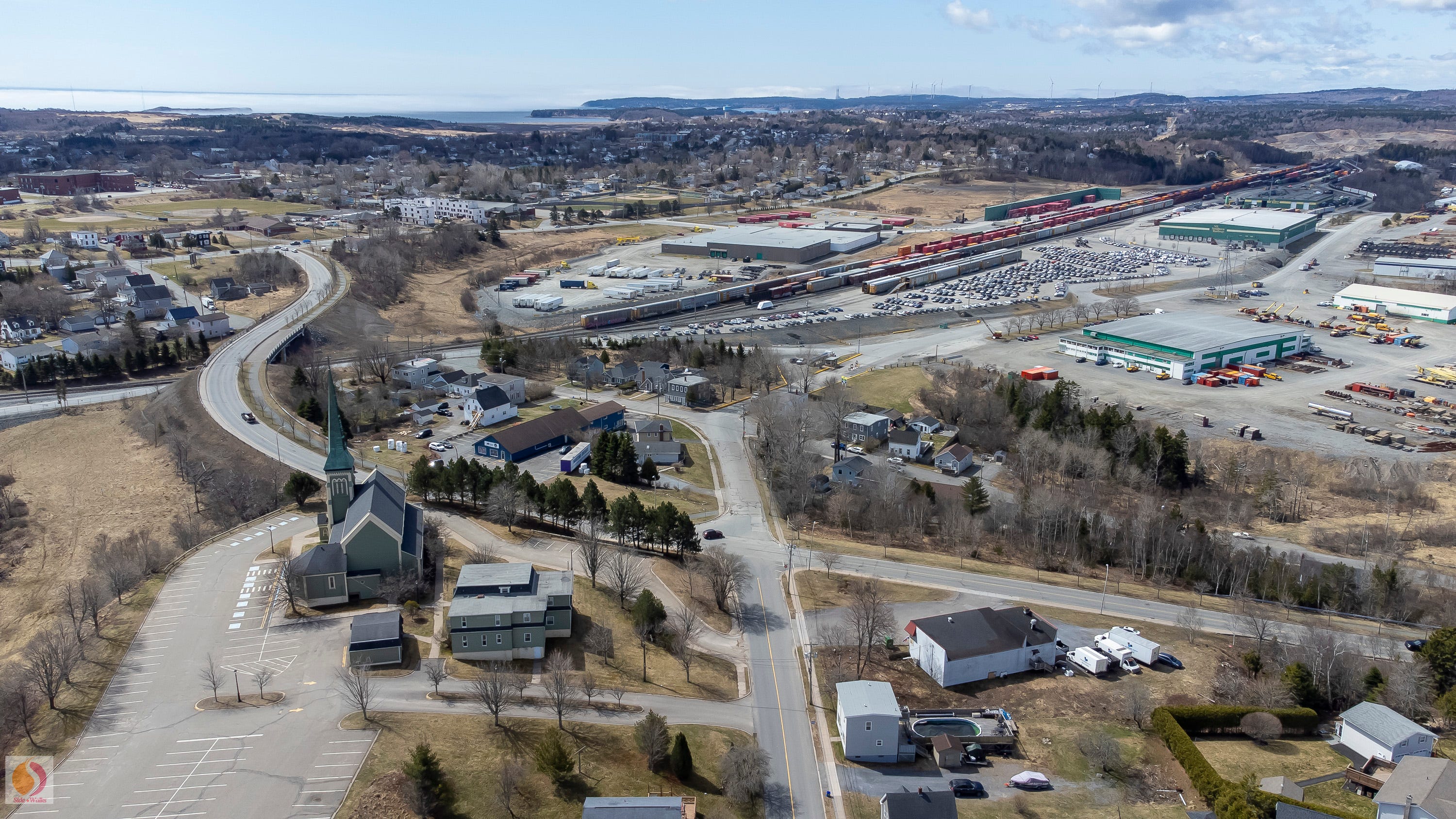
On the horizon sit Saint John Energy’s Burchill Wind Project turbines, and to the left, NB Power’s Coleson Cove power generator’s twin stacks, New Brunswick’s largest power plant, with 25 per cent of NB Power’s total generating capacity.
It’s located in the semi-rural community of Lorneville, located within the City of Saint John’s municipal boundaries. The City intends to expand Lorneville’s existing Spruce Lake Industrial Park to help attract significant domestic and foreign investment, positioning the area as ideal for green energy, data centres and a second logistics hub, because of its location near Port Saint John’s intermodal hub.
Moving left, along the coast, we see the Irving Nature Park, the spit of land jutting into the Bay of Fundy, and directly to the right, Saint John’s blue water tower, visible to drivers at the junction of Highways 1 and 7. Saint John’s famous Bay of Fundy fog hovers just off the coast and between it and the Logistics Park sits West Saint John, with apartment buildings, homes, ball diamonds and Barnhill Memorial School (far left) visible.
The Digby Ferry Terminal and Port Saint John’s container terminal are located just out of the frame.
Looking South Along The National Trade Corridor to Port Saint John
We’re back where we started, next to the Logistics Park, this time looking south. That’s Dever Road running up the centre, with Green Head Road to the left, its rail overpass clearly visible.
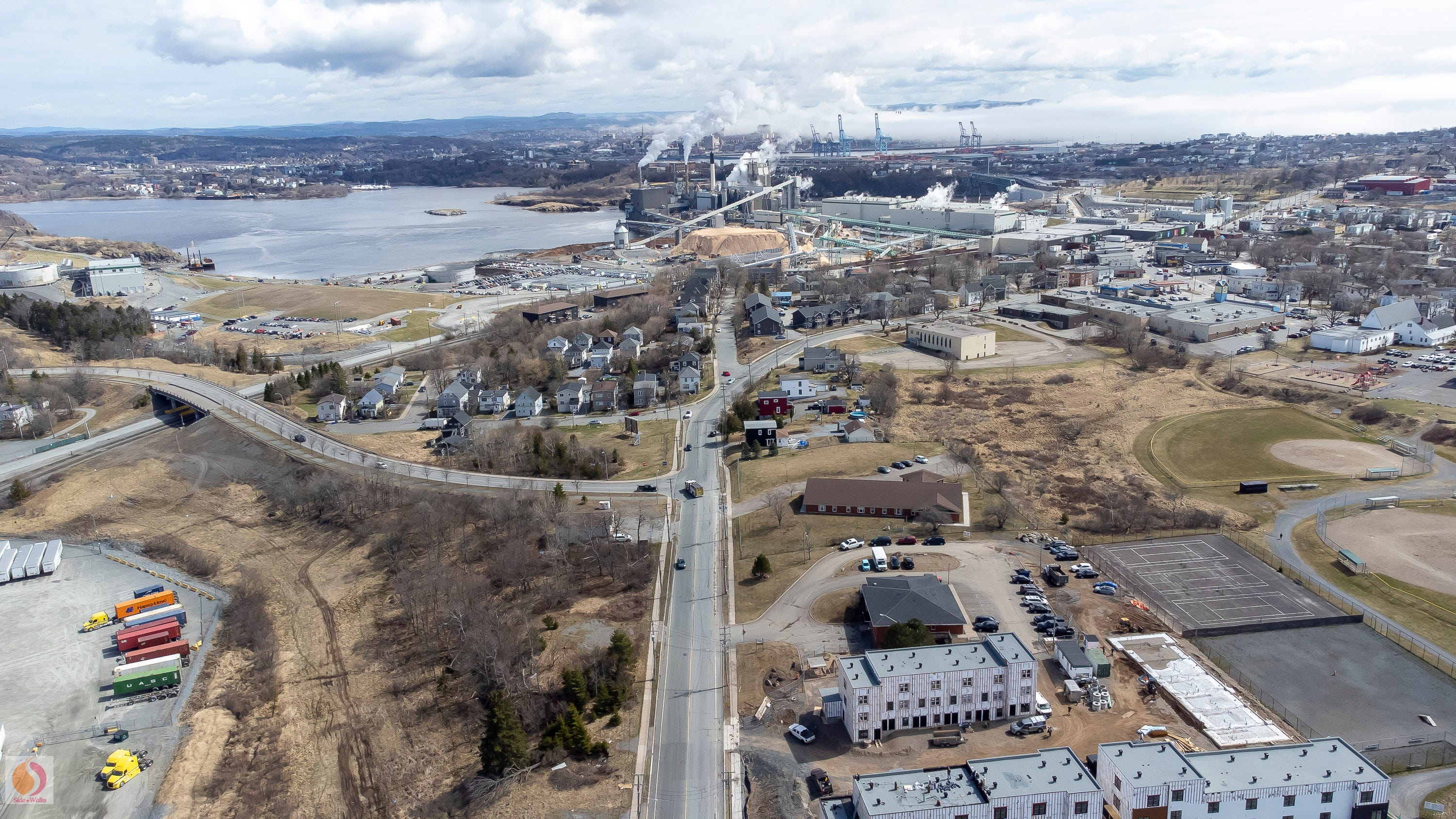
We have a full view of the Irving Pulp and Paper property, which extends from Green Head Road to Simms Corner, which you can just make out on the right side, in front of the New Brunswick Museum’s temporary home (red building).
Wolostoq Park sits just beyond Moosehead Breweries’ silos, the brewery identifiable by the green, red and blue billboards afixed to its brown walls. Behind it, Bridge Street curves towards Reversing Falls Bridge, connecting West Saint John with the rest of the city.
In the distance, Port Saint John’s six cranes tower over its West Side container terminal, with ochre, orange and burgundy containers visible beyond the house rooftops of the Lower West Side.
To the right of the containers is the American Iron and Metal scrapyard, which had its licence revoked by the provincial government in 2023 following a significant fire and after years of noise complaints from residents on both sides of the harbour. Saint John Council recently amended its zoning bylaws to limit scrapyards and salvage yards to heavy industrial zones, further away from residential areas.
Across the harbour, Uptown Saint John is visible beyond the fog, with Irving Oil’s headquarters the highest point. Brunswick Square is visible to the left.
Fallsview Park and Harbour View High School are located on the eastern bank, visible between the smokestacks. The white tarps of the Saint John Power Boat Club can be seen on the far bank, and further left, travelling up the River, is the Old North End.
Where Canada’s National Trade Corridor Turns The Corner
We arrive at Simms Corner. From this vantage point, we are looking east, and you can see the churn of Reversing Falls and Fallsview Park.
Starting in the centre and moving clockwise, we have: Bridge Street, which runs between the pulp mill and Wolostoq Park; Lancaster Avenue, which widens at Simms Corner and is the main route through the Lower West Side towards Port Saint John; Fairville Boulevard, which is a major West Side thoroughfare, until it reaches Simms Corner, where it narrows into a one-way eastbound street; and Main Street, which runs along the pulp mill and Moosehead Breweries, intersecting with Dever Road.
The Tim Horton’s/Wendy’s parking lot can be seen on the left side of the photo, between Main Street and Fairville Boulevard. Also visible is the NB Southern train track, which crosses both streets en route to Port Saint John’s container terminal.
You can see construction has begun at the pulp mill, where Irving Pulp and Paper’s 20-storey green energy generator will be located, which, when completed, will rival Saint John’s Brunswick Square and Moncton’s Assomption Place as the tallest buildings in New Brunswick.
To the right is the J.D. Irving-owned Wolostoq Park, which the company sought to have rezoned to use one-third of the park for a 500-spot contractor parking lot for the NextGen project. Saint John Council rejected its request for a permanent rezoning and countered with a five-year rezoning for a temporary parking lot, which J.D. Irving rejected.
In the foreground on the right, the brown Canadian Union of Public Employees (CUPE) local office sits at the southeast corner, just in front of the train track.
Beside it, the New Brunswick Museum’s temporary Research and Collections Centre, being used to store the Museum’s collections while the new museum is built on the other side of Reversing Falls, in an area located just above Fallsview Park. In this photo, the new location is obstructed by trees, behind Harbour View High School.
On the far right side, Highway 1’s Harbour Bridge can be seen crossing the mouth of the St. John River. It and the Reversing Falls Bridge are the only roadways connecting West Saint John and the rest of the city.
The Harbour Bridge is in the midst of a massive refurbishment project, which will extend its lifespan by at least 30 years. Construction began in 2021 and will end in 2027, which means traffic is often reduced to one lane either entering or leaving the city, which causes significant congestion on both west side bridges, as Saint John residents commute to school, work and social activities.
There’s No Side Like the West Side
A final look at Saint John’s West Side, looking west, along Lancaster Avenue, with Wolostoq Park in the foreground.
That’s Riverview Avenue West snaking in front, with a single home and the overflow parking lot for the Reversing Falls Restaurant and tourist lookout (not seen). Castle Fallsview Funeral Home is the blue building to the left.
Trees obscure the Simms Corner intersection, but the familiar Tim Hortons/Wendy’s signs can be seen poking out just above the tree tops.
To the left is Fairville Boulevard, which widens and returns to two-way traffic at Lancaster Mall, its parking lot visible in the upper left. According to City of Saint John planners, J.D. Irving’s proposed parking lot for Wolostoq Park would have been of similar size.
The Shoppers Drug Mart and Kent Building Supplies sit on either side of the major West Side intersection of Fairville Boulevard and Catherwood Street, with the on and off ramps for Highway 1 located just out of the frame, to the left.
Beyond the intersection is the West Side’s box store commercial area, and above it, on the bluff, are the homes and apartments visible to travellers on Highway 1 as they travel in and out of Saint John.
Returning to Simms Corner, your eyes can follow the box cars as they snake past Moosehead Breweries and Irving Pulp and Paper towards the familiar green walls of the NB Southern rail yard, part of J.D. Irving’s Logistics Park. To the right, you can see St. Rose Catholic Church, which marks the entrance to Milford, and beyond it, the St. John River’s South Bay, bringing us full circle
From these photos, it is obvious that change isn’t coming to West Saint John; it’s already here.
Residents know it. They know it because they sit in traffic, they hear the trains, and they see the ships that now come to call.
What they don’t have is a full understanding of the big picture and what it means for them and the city that seeks to be an Eastern gateway into Canada’s national trade corridor.
Other Stories in Our Series - Saint John at the Crossroads
Saint John’s New Trade Frontier: Tracks, trucks, and trade: The port city is building a new logistics future that will require significant coordination across the region – and cooperation closer to home.
Saint John’s Second Act: Global alliances, private investments, and cold chain innovations are transforming the Port of Saint John, but the real test will come inland.
Will Saint John Get on Board? Talk of a possible $70-million overpass for Simms Corner brings Canada's newly assertive trade agenda home to New Brunswick's Port City.
The Corner At The Centre of Things: Canada's muscular new trade agenda is picking up speed; are the neighbourhoods in and around Simms Corner in West Saint John ready for what's coming down the track?
Side Walks Home Page
Catch up on all our stories.