

River Watch Opens Into the Storm
BOOK EXCERPT: The Wolostoq/St. John River is hard to predict and our development choices don't make it easier

Stories connect us.
If this essay resonates with you, please share it. That’s how you can help us build a community of readers who care about supporting East Coast voices in our national conversation.
The Government of New Brunswick’s annual Flood Watch notification program has opened for the 2026 freshet season, providing residents with updates on river conditions, including possible ice jams and flood risks. In 2018, I wrote New Brunswick Underwater, which told the story of that spring’s flood, a historic once-in-one-hundred years flood. Then it happened again in 2019. Below is an excerpt that explains how experts monitor and regulate the Wolostoq/St. John River.
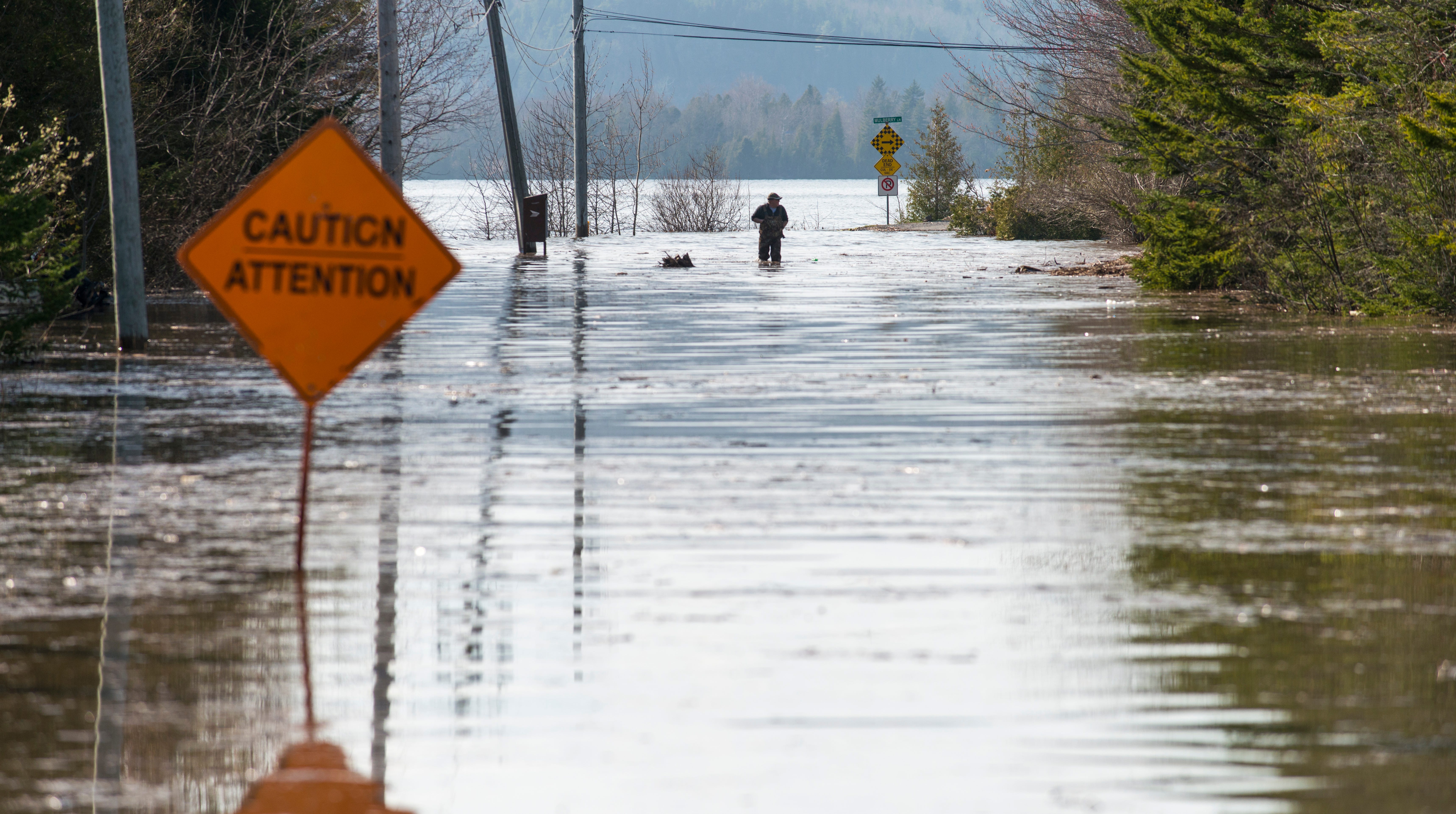
For 20 days in spring 2018, Wolastoq/St. John River reasserted its power over the land and people of central and southern New Brunswick. Water barrelled through the southern reach of the river at over 328,000 cubic feet per second – four times its normal rate – damaging over 12,000 homes, cottages and buildings, washing out roads and bridges and requiring $39 million in federal disaster relief.
The 2018 Wolastoq/St. John River flood was historic not only for what it did, but also for what it represented. This was New Brunswick’s eighth climate-related natural disaster in six years, all caused by fresh water – rain, snow and floods.
According to the New Brunswick Department of Environment and Local Government, climate change will lead to warmer winter temperatures, a rise in total precipitation falling in fewer but more intense events, more frequent winter thaws and larger fluctuations in river runoff.
Check, check, check and check.
“I believe there will be more events and we need to start preparing for what comes next,” said Saint John Fire Chief Kevin Clifford. “Those of us in disaster relief have a term for that: build back better. Citizens are always going to want to be close to nature but maybe we could take a step back.”
Forecasting the Flood
New Brunswick’s flood forecasting is produced by the Hydrology Centre within the Department of Environment and Local Government. This is how it works. First thing in the morning the team receives a weather briefing from the Atlantic Storm Prediction Centre in Dartmouth, Nova Scotia that gives them the daily high and low temperatures, barometric pressure, wind speeds and direction, and chance of precipitation.
Next, the centre’s data technologist collects all the information from the water level gauges located all along the river, in Maine, Quebec and New Brunswick. This information is then given to the forecast engineer who combines the two sources of data to create the hydrological model, which calculates how much water is coming down the river.
This information is then shared with NB Power, which uses it to calculate how much water will need to pass through the dam.
Mactaquac Dam, like the Grand Falls and Beechwood dams upriver, is a run-of-river dam. That means the holding pond created by the dam doesn’t actually store much water. That’s because of the St. John River’s geography, which is too small and narrow to allow for a large storage area. Instead, the water that flows into the Mactaquac head pond flows quickly through the dam’s turbines, creating hydroelectricity. Any water not used for power generation must bypass the dam through its spill gates.
During normal operations, water passes through the dam at 80,000 cubic feet per second. However, the 2018 spring flood produced far more water. On April 27, the first day of the flood in Fredericton, water was passing through Mactaquac at 297,000 cubic feet per second, over three times its normal rate. The next day – when the flood reached Maugerville – the water was at 327,000 cubic feet per second. It did not return to normal levels until May 13.
To enable the water to flow through the dam and its spill gates the river must approach Mactaquac at a downward angle, just as it used to before the dam was built. In order to achieve this slope, operators lower the head pond, which is why, according to NB Power and NB EMO, the head pond was so low during the flood.
Once NB Power has calculated its discharge levels for the day, the number is sent back to the Hydrology Centre to make a third and final calculation: the hydraulic forecast, which calculates the height of the water.
This requires three numbers: the hydrological forecast (water flow), NB Power’s water discharge estimate, and the height and timing of the Bay of Fundy tides. This final number allows forecasters to determine how much water will be able to pass through Reversing Falls and how much will be held back, left to linger in the lower reaches of the river basin.
It is the hydrological forecast that is delivered to NB EMO and then published on River Watch.
There is one fact that residents, experts, scientists and first responders can all agree: the five-day forecast is really a best guess thanks to New Brunswick’s fast-changing weather patterns.
The flood forecast, just like a regular weather forecast, increases in accuracy the closer it gets to the actual day.
New Brunswick was the first province in Atlantic Canada to introduce flood forecasting and flood mapping, which it did following the last historic flood, in 1973, basing its new system off the one developed for Manitoba’s Red River basin. Brian Barnes was one of the people tasked with creating it and remembers all too well the challenges of predicting Maritime weather patterns.
“The problem with flood forecasting in the East is weather. It happens very fast in a small area and the biggest problem is forecasting where the rain is going to fall,” he said, looking out at the St. John River from his living room in Fredericton. “By comparison the Red River is very big.”
The basis of flood forecasting is much the same now as it was then. To determine the level and speed of a flood, forecasters need to understand weather, rainfall, snowpack up north, daytime and nighttime high and low temperatures. Combined, these factors give an indication of how fast or slow the snow will melt in the upper reaches of the river system, in Maine, Quebec and northern New Brunswick.
Barnes says a lot has changed in New Brunswick over the past four decades. “Human geography was different then. The province was more rural,” he said, adding over the years economic considerations have oftentimes taken precedence over ecological realities. “We came out with flood risk mapping so the public could understand, but local politicians, real estate associations, municipalities and planning committees didn’t want to limit development.”
Matt Alexander understands too well the push and pull between land development and environmental protection. An environmental engineer by profession, Alexander is also the Deputy Mayor of Rothesay, a bedroom community that experienced flooding this year along the ribbon of residential development that runs along the banks of the Kennebecasis River.
Alexander says he sees the landscape changing as more people use the land, cutting down trees to improve their view of the river. It is further evidence he says of New Brunswick’s longstanding practise to allow low-density development, known as ribbon development, sometimes through granting exceptions to planning bylaws, and sometimes by simply not prosecuting offenders.
“Over the years we’ve really seen the Department of Environment whittle away. There really isn’t anyone out there to enforce the rules.”
Alexander says stronger enforcement of existing regulations under New Brunswick’s Watercourse and Wetlands Alterations regulation (WAWA) is a good place to start. In the wake of the 2018 flood, the provincial government announced plans to introduce new requirements for people and developers applying to build near rivers, streams and brooks to prove the project will withstand future flood damage. However, the existing WAWA regulations only apply to buildings within 30 metres of a watercourse or wetland – and the 2018 flood destroyed buildings set much further back from the shoreline.
Shawn Dalton understands the difficulty in trying to limit river-facing development along the St. John River. She is a Fredericton-based social ecologist and one of the authors of the Canadian Rivers Institute report on the St. John River and recognizes the desire to live and work along the river runs deep in New Brunswickers.
“We have a big problem on our hands when it comes to storm surges and floods. We’re on water and we will not back off it,” she says. “People expect the river not to move but rivers move. Rivers wander around their flood plains and flood plains are big. If you build in a flood plain you are going to get slammed.”
Dalton says as more trees are removed from the shoreline, whether through industrial forestry operations, agriculture, residential development or a simple desire for a view of the river, people can expect greater degradation of the shoreline, including erosion and flooding.
“We see more and more people moving out into the country and building with an urban aesthetic. I’d like to know if there were different impacts of the flood on people because of shoreline management,” she said. “We created this. It’s a climate event – and this is going to happen more.”
Support Local Reporting & Analysis
Want more insightful commentary like this? Becoming a paying supporter of Side Walks and follow our continuing coverage of the issues shaping Atlantic Canada’s future.
Stroll Over to Side Walks For More Stories


AI Summary: New Brunswick’s River Watch program launched today just as a major storm brings heavy rain and sleet to the province, raising concerns about flooding along the Wolastoq/St. John River. The St. John River system is one of the hardest in Canada to forecast because of its complex topography, unpredictable weather patterns, and fast‑changing flow rates. Experts say our ongoing development along riverbanks and floodplains – often in areas known to be at risk – makes forecasting even more challenging and increases the likelihood of severe damage during high‑water events. As the storm moves in, River Watch provides early warnings, but the long‑term risks remain tied to how and where New Brunswick builds.